Thank you! Your submission has been received!
Oops! Something went wrong while submitting the form. Please try again.

In June 2025, whilst leading a field school at an abandoned post-industrial diamond-mining site near Kimberley, South Africa, I chanced upon a scarab beetle. A scarab beetle in stone, approximately 2 metres in length and 1.5 metres in width. The wing covers, thorax and head of the stone beetle were covered by petroglyphs of human and humanoid forms, as well as rhinoceroses, eland and abstract geometric etchings. Transfiguring the whole were the scratchings of quasi-literate vandals dating from 1898 onwards. On the scattered dolerite boulders surrounding the scarab were scores of further petroglyphs.
In the first instance, I was literally gob-smacked by the beauty and power of the stone scarab and its etchings. A sense of wonder and appreciation that extended beyond the aesthetic to a sensed glimpse of a worldview that had since been destroyed. To be sure, the stone scarab is the result of the natural weathering and erosion of a dolerite dyke that punched its way through the sediments of the geological sequence known as the Karoo Supergroup. But its subsequent petroglyphic modification was the result of conscious human action directed by a specific understanding of the world.
The people and the worldview that etched the petroglyphs have disappeared, driven off by the combined forces of settler colonialism and industrial mining. This paper, whilst focussing on the stone scarab beetle, seeks to draw to the fore traces of the worldview that created such a work of art. The paper is based on historical, ethnographic and archaeological data relating to the first peoples of the Northern Cape of South Africa. The paper demonstrates that the scarab beetle was a work of art that situated humankind within a landscape diametrically opposed to that of settler colonialism and industrial mining.
The stone scarab is to be found on the farm Rooifontein, near to Kimberley, in the Northern Cape of South Africa, which is owned by the Ekapa Mining company.[1] A map of the city of Kimberley and its environs in 1892 depicts the “Diamond Floors”, of which Rooifontein was a part, that surrounded the mines. The floors were extensive tracts of land from which all vegetation had been removed and upon which mined diamondiferous Kimberlite ore was spread out and allowed to weather before being processed further. As the mechanical processing of Kimberlite developed, the floors became unnecessary to the production of diamonds. In some instances the desolate floors became the site for newly developed African housing projects within the context of apartheid legislation, and in one specific instance the abandoned floors became the site of the Wildlife Reserve Rooifontein. [2]
Currently Rooifontein forms a physical buffer zone surrounding the diamond processing zone of the Ekapa diamond mining company at the Bultfontein, Du Toitspan and Wesselton mines in contemporary Kimberley. Being a Wildlife Reserve, access to Rooifontein is strictly controlled and monitored, which is beneficial to Ekapa as it literally keeps unwanted elements, to wit Zama Zama informal miners, at a distance. Rooifontein is presented on the Ekapa website as part of the “environmental projects” of the diamond mining company where birdlife is stimulated, and wildlife has been introduced and marketed in terms of furthering biodiversity. Rooifontein is marketed in a number of varying guises, as a “Wildlife Club”, “Wildlife Conservancy”, “Nature Reserve”, “Game Reserve”, or “Game Farm”.[3] Sadly, aside from these lofty aspirations, Rooifontein is also the site of extensive canned hunting and the cynical use of environmental whitewashing as a security device to protect diamond mining interests.
Rooifontein has, none the less, consistently been a place that I have looked forward to visiting and visited with pleasure in the past five years. Rooifontein is a place of relief from the grind of archival and library research in the deeply depressing setting that is Kimberley, an imploding city of urban decay, rampant corruption, and lost dreams. In the context of almost apocalyptical urban decay, Rooifontein represents a site of peace and tranquillity within sight of industrial diamond mining and urban sprawl. Each visit has left me, and continues to leave me, in awe of the beauty and power of life, the ability of life to insinuate itself where ever it can. But with time, I have also come to learn more and more about the area that was initially presented to me as pristine nature. Over time, I have come to learn that Rooifontein, far from being virgin territory, is the site of extensive and intensive industrial mining, overlain on a terrain of deep historical depth and importance.
At Rooifontein friends and I have often had sundowners at the site of a water tower that was built on a small dolerite ridge that trends north to south and forms a conspicuous element in the landscape. Sitting at the foot of the water tower one has wonderful views of the sun setting over the mine dumps and the emerging twinkling lights of the city of Kimberley. During these numerous visits I became aware of the fact that the second and smaller ridge further to the south of the water tower had been the site of a Boer Artillery emplacement during the siege of Kimberley in the Anglo-Boer War. The graffiti of Boer combatants was to be found scrawled on the dolerite boulders. In the course of the five years that I have visited Rooifontein, I must have traversed that small dolerite ridge at least thirty times, and I was aware of earlier images that predated those of the Anglo-Boer War; but the full import of those images and their setting was still lost to me.
In June 2025 I led a field school for my students at Rooifontein. We took the water tower as the starting point for four traverses across the land that were set out to the cardinal points of the compass. I had given the southern traverse to one student in particular as I was aware of their interest in military history, and was certain that they would discover the Boer graffiti and possibly even recognise the gun emplacement. In the event, I was not disappointed, and as the team traipsed across the ridge to see the graffiti, I suddenly recognised a rock for what it was, a rhinoceros rubbing stone.[4] An enormous dolerite boulder that has been smoothed over countless years by rhinoceros’ rubbing against the rock to ease an itch.[5] In the early 1990s, I had conducted research in Namibia and had marvelled at the rhino-rubbing stone placed at the entrance of the museum in Windhoek. Recognising the rock for what it was in Rooifontein, I hopped on top of it, and there before me I saw the scarab. And, once I had seen it, I could not unsee it.
Dusk projected a mellow reddish light which caused the engraved part of the boulders to stand out sharply, conferring on the already fading images an unexpected, ephemeral visibility. It was as if they suddenly existed in that vanishing light, which thus became the primary reason for their existence. Once this instant of splendour had passed, images and boulders vanished.[6]
Apropos, if you see the “Boer rock” from another angle, you simply do not see the etching. It is striking to see how dependent one is on the angle of light to see the engravings, one can literally be less than two metres away and not see an engraving unless one turns one's position to another angle.[7]
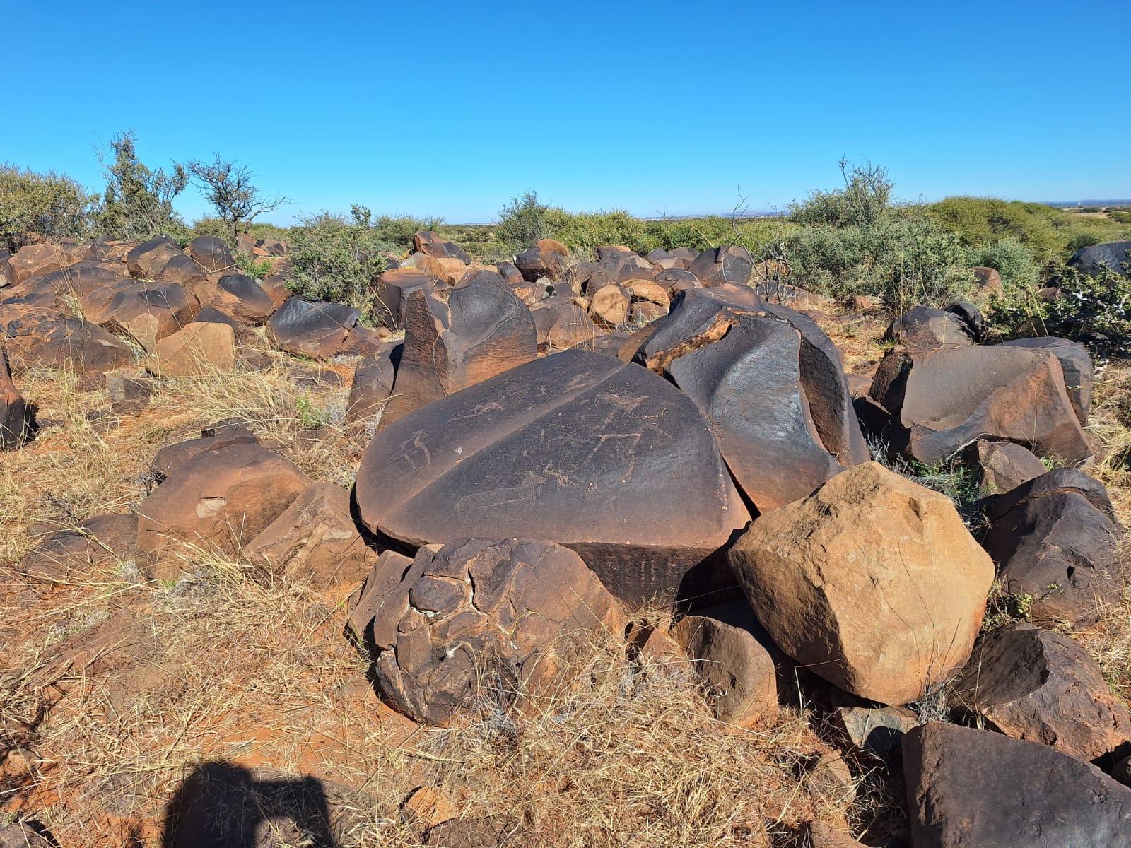
The Scarab is formed by the natural weathering of a dolerite dyke. It is surrounded by boulders, many of which have been broken, tumbled, displaced and defaced by humans in the past 150 years. In addition, the Scarab is surrounded by a large number of naturally formed small rock pools that will contain water after rain or mist. The Scarab is aligned East to West with it head facing due West towards a lower lying vlei. In the past this vlei would have been covered with the run-off of the spring that used to be known as Olifantsfontein, which is associated with the contact zone where the impervious dolerite dyke punched it way through the Dwyka shales. That is, the dolerite dyke, part of which weathered to become the Scarab, is also the natural cause for the existence of the perennial spring known as Olifantsfontein.
The Scarab sits in a circle of rocks, at least two of which are rhino rubbing stones that are still in situ. The Scarab is approximately 1,50 metres in breadth and 2 metres in length. The two wing covers that cover the thorax are covered by numerous etchings of animals and designs. The images include Eland, Rhinoceros, horned buck, possible lion, and geometric designs. In addition P.F. Marais has been scrawled across the top of the right hand wing panel, and AD 16 on the lower left wing cover. The abdomen of the Scarab, which has weathered into two halves, contains a large anthropomorphic figure on the upper left side, and a large buck, possibly an eland on the right side. The head itself appears not to have any engravings on it.
The Scarab sits on the small dolerite ridge surrounded by countless dolerite boulders and sills. Due to natural weathering many of the stones form natural bowls or containers into which water collects as rainfall or mist. Large numbers of the dolerite boulders have been marked by conscious human action. This ranges from breaking and tumbling rocks, through to covering them with designs, or scratching images and signatures on to them. The ridge itself is approximately 150 metres in length and 50 metres in width. Less than forty metres to the South of the Scarab lie the remains of an artillery emplacement which had been established by the Orange Free State Boer forces under the command of Hoof Commandant Cornelis (Kerneels) Janse Wessels.[8] The Kroonstad Commando established their position at Olifantsfontein in early November 1899, and would maintain this position till the lifting of the siege of Kimberley on 15 February 1900. During this period of time Boer artillery shelled Kimberley, and Boer positions were shelled in return. It is clear that much of the defacement of the dolerite boulders on the ridge was carried out by men under the command of Wessels during the siege of Kimberley in which the Boer forces of the Kroonstad Commando were stationed at Olifantsfontein.
The petroglyphs on the rocks conform to similar dolerite sites in the Northern Cape and Northwest Province. That is that the pre-colonial rock engravings broadly consist of three types, striations, scraping, and pecking. In each case the oxidised patina that has developed on the outer layer of a dolerite boulder has been scratched, scraped or pecked away to bring to the fore the lighter unoxidized dolerite lying below. The images come to the fore in very specific settings dependent upon the angle of light falling on them. Many a time one can be looking directly at an image and see nothing, only to look at the same spot from a different angle or at a different time of day, and see the image in perfect clarity. Following my initial finding of the Scarab on an early overcast winter morning in July, my students and I had found many more images. When I returned to the site in the latter part of a clear day in October a few months later I was no longer able to find many of the images that I had seen in July. It was only in returning to the site on an overcast day in December, and spending the whole day traversing the dolerite ridge from east to west and from north to south that I was once again able to find images that I had spotted in July, but had remained elusive in October.
My conscious traversing of the dolerite ridge in December allowed me to gain a better understanding of the position of the Scarab, as well as gain an overview of the different types of rock engraving on the Kopje. In addition, I was able to make a little sense of the human detritus of war that I found. My notebook records the large amount of lithics, many of which must have been carried in from a fair distance as they are made of red quartz referred to locally as “Rooi Kopje Klippe”, and used by diamond hunters as an indicator for alluvial diamonds. In addition, my notes refer to the almost ubiquitous presence of green glass shards, the remnants of thick handblown glass bottles of substantial size all along the ridge. None of these shards have been modified and are probably remnants of drink bottles associated with the Kroonstad Commando in the Anglo-Boer War. Similarly rusting pieces of packing case strips and small iron tacks associated with packing cases, possibly for artillery rounds, are to be found all along the ridge and are also probably associated with the Boer War. As are flattened tins, including paraffin tins, and strands of 3 – 4 mm thick wire, a chest lock, and a parasol rib. The presence of a large pieces of shrapnel, as well as “splatter marks” on the rocks indicate that British gunners in Kimberley had the ridge within range, and that incoming artillery rounds found their target.[9]
The graffiti defacement associated with the Boer War ranges from the semi-literate vandalism of Marais, who consistently inscribes his S the wrong way round, and his colleagues, through to what at first appeared to be a series of Tswana names, and the extremely distinguished and fine copper-plate of “W.A. Barnard, Kroonstad Laager, 1 November 1899”. Part of this defacement, on a large rock overlooking Kimberley in the distance, the image of a quagga has been defaced by the tag of “WP”, whereby the forelegs of the earlier quagga form part of the W. On two rocks the scraped images of sheep surrounded by striations are to be found. In two instances what appears to be a stylised ox-drawn plough are to be found. Of these one is to be found with a listing of Sesotho words and appears to be contemporaneous with the list. These names are possibly those of the Sotho Agterryers employed by the Boer Commando for physical labour. A rough Google Translate of the text reads as follows: “The ten words [commandments] that come out of the mouth of the Lord are the words of the Lord”.[10]
The work of many has drawn to the fore the importance of rock art in southern Africa to those that made it, as well as to those who saw it and used it. Most notably recently has been the work of José Manuel de Prada-Samper, particularly his book, Fading Footprints: In search of South Africa's first people, that has highlighted the immensity of the crime committed in the genocidal killing of the /Xam people of South Africa.[11] Within academia the full extent of the genocide, as well as the historiographic debates it ignited, has been well documented.[12] Particularly, with regard to the cultural loss engendered by genocide; the loss forever of aspects of culture that brought the world to life, both literally and figuratively. But, the listing of dates and details does not return to us the immaterial that made life and the world around it intelligible. The consciously made traces of people left on the landscape have been robbed of the people who could make these traces intelligible, they have been killed, and thus effectively silenced forever.
Large numbers of academics have attempted to make sense of the traces left on the landscape of these exterminated people. The debate as to how to interpret these traces has at times been particularly fractious and factional. Essentially the debate boils down to one of two extreme positions. On the one hand, those that argue that the traces are attempts at representing metaphysical experiences associated with dreamtime, and on the other hand those who would argue that the traces are attempts at representing real historical events and incidents. In both instances, these attempts at decoding the traces on the rocks have ranged from the insipidly antiquarian through to the truly inspired.[13] Generally academics have drawn on the extensive ethnographic research conducted amongst the Kalahari Bushmen in the years after World War II in combination with details taken from the extensive Bleek and Lloyd archive to come to comments and suggestions relating to the rock art that is to be found throughout southern Africa and which is generally referred to as “Bushmen Paintings/Rock Art”.
In South Africa large numbers of academics have focussed on rock art, but it has been the work of Janette Deacon in particular that has focussed on the rock art associated with the /Xam. Central to this has been the extensive Bleek and Lloyd archive of /Xam material, collected and transcribed from /Xam Bushmen sentenced to work as convicts on the breakwater in Cape Town in the 1870s.[14] The work of David Lewis-Williams and Sam Challis deals extensively with “San Bushman Rock Art” and suggests that the rock art, in conjunction with ethnographic texts (which includes the Bleek and Lloyd archive), constitute, as it were, a Rosetta Stone that allows us to gain insight into and understand the social world of the people who created this art.[15] The archaeologist, David Morris, whilst also drawing on a slew of ethnographic data, has actively sought to lift the debate with regard to rock art beyond ethnicity in the Northern Cape, particularly with his MA thesis dealing with rock art at a site known as Driekopseiland in the Riet river near to Kimberley, as well as his subsequent PhD thesis that included the site at Wildebeestkuil, also near to Kimberley.[16] It is the work by Sven Ouzman on Thabo Sione that resonates most strongly with my own work on Olifantsfontein, and demonstrates that the Scarab, and the rock art associated with it, is part of a continuum that extends from the Karoo through to the North West Province of South Africa.
The 19th [century] /Xam Bushmen of the Upper Karoo, South Africa, told stories about a protean being called !khwa: (“water”), one of whose many shapes was that of a bovine they called “the water bull”, which ritual specialists captured in order to cause rain over the land.[17] The available ethnographic evidence indicates that the rock engravings inscribed on burnished dolerite boulders that stretch across South Africa are associated with rain-making rituals. It is clear that Olifantsfontein was one such site, unfortunately its /Xam name has been lost to us. Fortunately we can catch a glimpse of the worldview that would have informed Olifantsfontein prior to the 1860s.
Drawing upon the ethnographic evidence drawn together in the Bleek and Lloyd archive, and subsequently developed by numerous others (Janette Deacon and José Manuel de Prada-Semper in particular) we can see that for the /Xam Bushmen water was a living being called !khwa that could be interceded with by specialists. One such specialist was , //Kabbo, whose name meant Dream, which marked him as a “hunter, sorcerer and rain’s man”.[18] //Kabbo’s fellow /Xam informant, Dia!kwain told Bleek and Lloyd that his ancestors had inscribed the rocks, and that they had engaged in rainmaking.[19] Ritual specialists who interceded with water, which could manifest itself as a “water bull”, were known as !giten. The term “water bull” is an English Gloss for !khwa:-ka xoro for when water manifests itself as a quadruped. [20]
!Giten, such as //Kabbo, would go to specific spots associated with a permanent water source, and there they would conduct rituals to contact, interact with and control !khwa.[21] De Prada-Samper notes that “the !khwa: of /Xam stories and beliefs can be touched and smelled. It can be seen grazing outside its abode, flying in the sky from place to place or walking with long legs over the plain”.[22] Dia!kwain described how rainmakers would go to specific spots directly associated with perennial water sources to capture and bring rain to their community.[23] !khwa as a “rain-animal” could and did manifest itself in a variety of forms ranging from snake to eland, through quadrupeds that look like rhinoceros, hippopotamus, or bull.[24] It is this “rain-animal” that is captured by the ritual specialist, led to lands that need rain, where upon it is cut to cause rain to fall.
Janette Deacon and de Prada-Samper suggest that the vertical and horizontal scratches that are to be found on many of the dolerite boulders, at times across the previously inscribed, engravings of “rain-animals”, are to be seen as the act of cutting to cause rain to fall.[25] Rain is in effect the blood of !khwa which after having been captured by the ritual specialist has been led to a particular place and cut. De Prada-Samper, drawing on Dia!kwain’s account, notes that it is clear “that the clouds were thought to emanate from the which was thus considered to be the dwelling of the living water. The creature, which was first liquid water inside a well, then mist, then clouds, then rain, actually embodies the whole water cycle”.[26]
The ritual significance of Scarab beetles is well documented for societies beyond South Africa.[27] It is clear from the Bleek and Lloyd archives that /Xam routinely consumed beetles.[28] Ratcliffe noted, that within southern Africa scarab beetles (probably Oryctes sp., possibly Augosoma centaurus) are eaten to acquire the “special powers” associated with these large beetles.[29] In addition as Arnold van Huis notes:
In South Africa respondents told me that the San use the pupae Diamphidia nigroornata (Chrysomelidae) as an arrow poison. To strengthen the poison, they mix it with certain plant extracts: Solanum coccineum (Solanaceae), Antizoma angustifalia (Menispermaceae), Boscia albitrunca (Capparaceae), and Acanthosycios naudinianus (Cucurbitaceae).[30]
Furthermore, Scarab beetles too, are directly associated with water and soft rains in particular. It is in the course of soft rains, the rains that were sought after in contrast to the destructive hard rains, that Scarab beetles roll and bury their balls of dung that are seeded with new life. A more fortuitous site for the stone Scarab cannot be imagined situated as it is surrounded by water and natural rock containers in which soft rains and mist can be collected.


Bearing the above in mind it is clear that the ridge at Olifantsfontein played a central role in rain rituals for the people who lived there prior to the 1860s. Give the aridity of the area, it is probable that these people would have been /Xam hunter-gatherers for whom Olifantsfontein, as the site of perennial water would have been extreme importance. It is more than likely that Olifantsfontein, as the site for elephants, will have fallen victim to the “imperial bullet” by the 1830s at the latest.[31] Bereft of thick tree cover or rocky ravines and valleys, the elephants that gave Olifantsfontein would have had inadequate cover or refuge to escape from the mounted fire armed hunters that emanated from the Cape Colony from the late 1700s onwards.
/Xam bushmen and their ancestors will have made use of the resources of Olifantsfontein for as long as humans have walked on planet earth. The heavily patinaed lithics found at the site, including the barely discernible vertical and horizontal scratching on the dolerite rocks, indicate the presence of humans and ritual activity that extends back into antiquity.[32] The naturally weathered bowls that abound along the ridge, will only have served to reenforce the importance of Olifantsfontein as a dwelling place of !khwa (water). Furthermore, those who came later, would have been aware of the perennial spring, and used that water for their purposes as well.
It is possible that, in line with Sven Ouzman’s work on Thaba Sione, further to the North East of Olifantsfontein, Sotho-Tswana speakers will have made use of the site for ritual purposes. The presence of a sacred text drawn from the bible and associated with stylised drawings of ox-drawn ploughs would underscore this point. If this is the case, then the Sotho-Tswana inscriptions will have predated the Anglo-Boer War, and possibly even the discovery of diamonds in the Kimberley area in 1870. By 1880, Olifantsfontein was firmly within the realm of the diamond mines of Kimberley, and its water source undoubtedly a source for the newly established mines.
As noted earlier, Olifantsfontein with its abundant water, formed the base of operations for Commandant Wessels and his commando when they besieged Kimberley in the Anglo-Boer War. After the war, Olifantsfontein as part of the farm Rooifontein, became subject to the monopolistic powers of De Beers Consolidated Diamond Mining. In the 1970s Rooifontein became in effect a buffer zone and private game farm for De Beers. A function that it continues to have in the present. In this the ritual significance of Olifantsfontein was not recognised.
The Scarab beetle that I stumbled upon in June, with its wing covers covered in animals closely associated with rain, is a unique trace of a way of looking at the world, and humankind’s position within it, that was virtually obliterated under the combined onslaught of imperialism and industrial mining.